
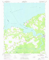
1953 Map of Columbia West
USGS Topo · Published 1956About this map
The Scuppernong River snakes through the heart of this coastal North Carolina landscape, serving as a primary artery for the town of Columbia and surrounding rural outposts. In the mid-1950s, the area's maritime identity is clearly defined by numerous river access points, including Simmons Landing, Back Landing, and Dunbars Landing. To the north, the waters of Albemarle Sound and Bull Bay dominate the horizon, where local recreation is noted at Norman Smith Legion Beach and Colonial Beach. Inland, small communities such as Travis and Woodley anchor the farming country, while the New Jerusalem Ch provides a focal point for local genealogy. The map also captures the transition from land to water through various landings like River Neck Landing, reflecting a period when river-based transport and small-scale landings remained vital to the regional economy and social structure.
Find a feature on this map
26 named features on this map. Tap any name to fly to it.
Don’t see what you’re looking for? This feature index may not catch every label — zoom into the map to look around manually.
Map Details
Editions of this 1953 Columbia West Map
2 editions found
Other maps of this area

1906 · Hertford
USGS Topo · 1:62,500

1940 · Hertford
USGS Topo · 1:62,500

1940 · Wade Point
USGS Topo · 1:62,500

1943 · Wade Point
USGS Topo · 1:62,500

1943 · Columbia
USGS Topo · 1:125,000

1948 · Wade Point
USGS Topo · 1:62,500

1953 · Norfolk
USGS Topo · 1:250,000

1953 · Columbia East
USGS Topo · 1:24,000

1953 · Scotia
USGS Topo · 1:24,000

1953 · Rocky Mount
USGS Topo · 1:250,000