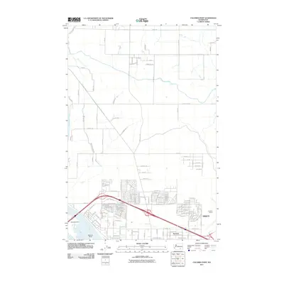
2011 Map of Columbia Point
USGS Topo · Published 2011About this map
The Columbia River and Yakima River converge at the southwest corner of this map, shaping the development of Pasco and the surrounding Franklin County landscape. In this 2011 record, the city’s northwestern expansion is evident through the dense residential street grids of Riverview and the proximity to the Tri-Cities Airport. The transition from urban center to irrigated agricultural land is clearly demarcated by the Pasco Pump Lateral Canal, which feeds a network of rural routes including Taylor Flats Rd and Selph Landing Rd. To the west, Columbia Point and Bateman Island stand as prominent riparian features at the river's edge, while the northern half of the sheet remains dominated by large tracts of land and a rectilinear road system typical of Washington’s interior agricultural heritage.
Find a feature on this map
91 named features on this map. Tap any name to fly to it.
Don’t see what you’re looking for? This feature index may not catch every label — zoom into the map to look around manually.
Map Details
Editions of this 2011 Columbia Point Map
This is the sole edition of this map. No revisions or reprints were ever made.
Other maps of this area

1917 · Pasco
USGS Topo · 1:125,000

1951 · Richland
USGS Topo · 1:62,500

1953 · Walla Walla
USGS Topo · 1:250,000

1958 · Walla Walla
USGS Topo · 1:250,000

1964 · Kennewick
USGS Topo · 1:24,000

1964 · Pasco
USGS Topo · 1:62,500
1964 · Pasco
USGS Topo · 1:24,000

1965 · Eltopia
USGS Topo · 1:62,500
1965 · Badger Mtn
USGS Topo · 1:24,000
1965 · Badger Mtn
USGS Topo · 1:62,500