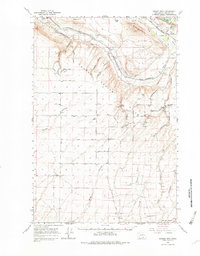
1965 Map of Badger Mtn
USGS Topo · Published 1982About this map
Benton County agriculture and infrastructure define this mid-1960s landscape, where the Northern Pacific Canal and various irrigation laterals like the West Badger Lateral wind through the valley. The settlement of Kiona sits near the Yakima River and the Union Pacific tracks, serving as a gateway to the dryland wheat country above. The plateau of the Horse Heaven hills is marked by small rural communities like Rome and Horseheaven, connected by an extensive grid of family-named roads including Reese Road and Quillen Road. This era shows a transition in local transport and utilities, evidenced by the Landing Strip near Henson Road and various Pipeline corridors cutting across Badger Mountain. The presence of numerous storage bins and a Grange Hall reflects the deep-rooted farming economy of the region.
Find a feature on this map
59 named features on this map. Tap any name to fly to it.
Don’t see what you’re looking for? This feature index may not catch every label — zoom into the map to look around manually.
Map Details
Editions of this 1965 Badger Mtn Map
This is the sole edition of this map. No revisions or reprints were ever made.
Other maps of this area

1906 · Blalock Island
USGS Topo · 1:125,000

1908 · Blalock Island
USGS Topo · 1:125,000

1908 · Umatilla
USGS Topo · 1:125,000

1915 · Prosser
USGS Topo · 1:125,000

1917 · Pasco
USGS Topo · 1:125,000

1917 · Prosser
USGS Topo · 1:125,000

1951 · Richland
USGS Topo · 1:62,500

1951 · Corral Canyon
USGS Topo · 1:62,500

1953 · Pendleton
USGS Topo · 1:250,000

1953 · Walla Walla
USGS Topo · 1:250,000