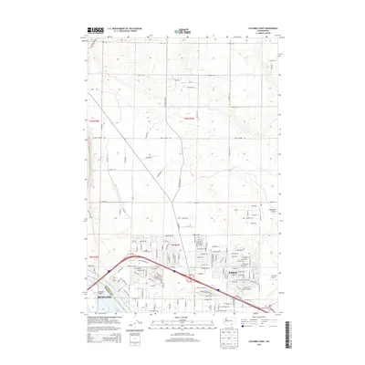
2014 Map of Columbia Point
USGS Topo · Published 2014About this map
Richland and Pasco meet at the confluence of the Columbia River, showcasing the modern suburban expansion and industrial infrastructure of the Tri-Cities region in the early 21st century. The map illustrates a landscape transitioning from the irrigated agricultural lands of the north, marked by the Pasco Pump Lateral Canal, to the dense residential developments and commercial corridors in the south. The southern portion of the sheet is dominated by the intricate road networks around Columbia Point and the prominent BNSF Railway corridor that serves the region's commerce. The contrast between the rugged natural depression of Esquatzel Coulee in the east and the precisely planned neighborhoods along Sandifur Pkwy and Chapel Hill Blvd highlights the significant human reshaping of the high desert environment to accommodate rapid urban growth.
Find a feature on this map
35 named features on this map. Tap any name to fly to it.
Don’t see what you’re looking for? This feature index may not catch every label — zoom into the map to look around manually.
Map Details
Editions of this 2014 Columbia Point Map
This is the sole edition of this map. No revisions or reprints were ever made.
Other maps of this area

1917 · Pasco
USGS Topo · 1:125,000

1951 · Richland
USGS Topo · 1:62,500

1953 · Walla Walla
USGS Topo · 1:250,000

1958 · Walla Walla
USGS Topo · 1:250,000

1964 · Kennewick
USGS Topo · 1:24,000

1964 · Pasco
USGS Topo · 1:62,500
1964 · Pasco
USGS Topo · 1:24,000

1965 · Eltopia
USGS Topo · 1:62,500
1965 · Badger Mtn
USGS Topo · 1:24,000
1965 · Badger Mtn
USGS Topo · 1:62,500