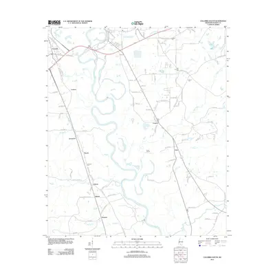
2012 Map of Columbia South
USGS Topo · Published 2012About this map
Pearl River meanders through this portion of Marion County, Mississippi, creating a landscape of oxbows and creek networks. Small settlements and rural community hubs such as Foxworth, Jamestown, Lovelace, and Pickwick are connected by a web of local roads, including Old Foxworth-Jamestown Rd and Old Highway 35 S. The presence of several historic burial grounds, such as Friendship Cem and Sunflower Cem, suggests long-standing family ties to the land.
Find a feature on this map
111 named features on this map. Tap any name to fly to it.
Don’t see what you’re looking for? This feature index may not catch every label — zoom into the map to look around manually.
Map Details
Editions of this 2012 Columbia South Map
This is the sole edition of this map. No revisions or reprints were ever made.
Other maps of this area

1953 · Hattiesburg
USGS Topo · 1:250,000

1958 · Hattiesburg
USGS Topo · 1:250,000

1969 · Baxterville SW
USGS Topo · 1:24,000

1969 · Pinebur
USGS Topo · 1:24,000

1970 · Columbia South
USGS Topo · 1:24,000

1970 · Sandy Hook NW
USGS Topo · 1:24,000
1970 · Dexter
USGS Topo · 1:24,000

1970 · Morgantown
USGS Topo · 1:24,000

1970 · Columbia North
USGS Topo · 1:24,000
1970 · Sandy Hook
USGS Topo · 1:24,000