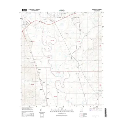
2015 Map of Columbia South
USGS Topo · Published 2015About this map
The Pearl River winds in deep oxbow loops through this Mississippi landscape, separating the city of Columbia from the neighboring community of Foxworth. This 2015 survey reveals a pattern of rural settlements and family-named roads that reflect the area's agricultural and timber history. Numerous small communities like Lovelace, Jamestown, Natcole, and Cheraw are connected by a network of local routes such as Old MS 35 and Hemmingtown Rd. The presence of several established cemeteries, including Woodlawn Cem and Friendship Cem, along with Porter Airport, indicates a well-developed local infrastructure established over generations. The drainage systems of Silver Cr and Tenmile Cr further define the terrain, illustrating how the river's floodplains have influenced the placement of homes and industry throughout Marion County.
Find a feature on this map
94 named features on this map. Tap any name to fly to it.
Don’t see what you’re looking for? This feature index may not catch every label — zoom into the map to look around manually.
Map Details
Editions of this 2015 Columbia South Map
This is the sole edition of this map. No revisions or reprints were ever made.
Other maps of this area

1953 · Hattiesburg
USGS Topo · 1:250,000

1958 · Hattiesburg
USGS Topo · 1:250,000

1969 · Baxterville SW
USGS Topo · 1:24,000

1969 · Pinebur
USGS Topo · 1:24,000

1970 · Columbia South
USGS Topo · 1:24,000

1970 · Sandy Hook NW
USGS Topo · 1:24,000
1970 · Dexter
USGS Topo · 1:24,000

1970 · Morgantown
USGS Topo · 1:24,000

1970 · Columbia North
USGS Topo · 1:24,000
1970 · Sandy Hook
USGS Topo · 1:24,000