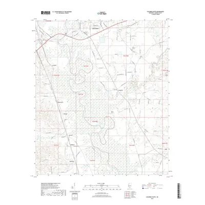
2018 Map of Columbia South
USGS Topo · Published 2018About this map
The Pearl River snakes through the center of this landscape south of Columbia, carving deep oxbows and creating a wide alluvial floodplain marked by dense wetlands. Settlement patterns follow the higher ground on either side of the river, where small communities like Lovelace, Lampton, and Jamestown are connected by a network of rural roads. The area's social history is anchored by numerous local burial grounds, including Sunflower Cem and New Zion Cem, which serve as landmarks for the surrounding homesteads. In the southern reaches, the settlements of Cheraw, Mildred, and Pickwick define the transition toward the piney woods and creek drainages of Tenmile Cr and Upper Little Cr. Private aviation infrastructure, such as Beets Airport and Porter Airport, reflects the modern utility of the land alongside traditional agricultural and river-adjacent life.
Find a feature on this map
84 named features on this map. Tap any name to fly to it.
Don’t see what you’re looking for? This feature index may not catch every label — zoom into the map to look around manually.
Map Details
Editions of this 2018 Columbia South Map
This is the sole edition of this map. No revisions or reprints were ever made.
Other maps of this area

1953 · Hattiesburg
USGS Topo · 1:250,000

1958 · Hattiesburg
USGS Topo · 1:250,000

1969 · Baxterville SW
USGS Topo · 1:24,000

1969 · Pinebur
USGS Topo · 1:24,000

1970 · Columbia South
USGS Topo · 1:24,000

1970 · Sandy Hook NW
USGS Topo · 1:24,000
1970 · Dexter
USGS Topo · 1:24,000

1970 · Morgantown
USGS Topo · 1:24,000

1970 · Columbia North
USGS Topo · 1:24,000
1970 · Sandy Hook
USGS Topo · 1:24,000