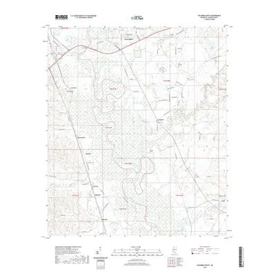
2020 Map of Columbia South
USGS Topo · Published 2020About this map
The Pearl River winds through the heart of this Marion County landscape, defining the low-lying terrain south of Columbia. This river corridor is flanked by a dense network of minor settlements and named locales, including Jamestown, Lovelace, and Natcole, which speak to the rural distribution of the region. The landscape is heavily marked by its water systems, from the meandering curves of Upper Little Creek to the convergence of Balls Mill Creek and Dillon Creek.
Find a feature on this map
89 named features on this map. Tap any name to fly to it.
Don’t see what you’re looking for? This feature index may not catch every label — zoom into the map to look around manually.
Map Details
Editions of this 2020 Columbia South Map
This is the sole edition of this map. No revisions or reprints were ever made.
Other maps of this area

1953 · Hattiesburg
USGS Topo · 1:250,000

1958 · Hattiesburg
USGS Topo · 1:250,000

1969 · Baxterville SW
USGS Topo · 1:24,000

1969 · Pinebur
USGS Topo · 1:24,000

1970 · Columbia South
USGS Topo · 1:24,000

1970 · Sandy Hook NW
USGS Topo · 1:24,000
1970 · Dexter
USGS Topo · 1:24,000

1970 · Morgantown
USGS Topo · 1:24,000

1970 · Columbia North
USGS Topo · 1:24,000
1970 · Sandy Hook
USGS Topo · 1:24,000