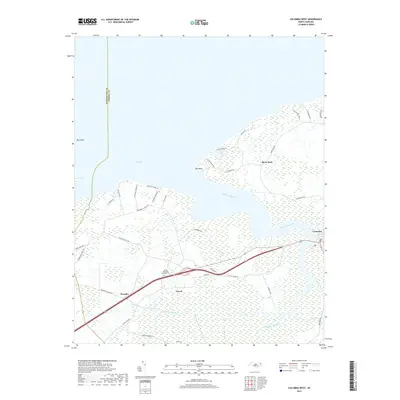
2019 Map of Columbia West
USGS Topo · Published 2019About this map
The Scuppernong River winds through this coastal landscape, serving as the primary drainage for the expansive wetlands that characterize the Tyrrell County interior. The town of Columbia sits at a strategic bend in the river, anchoring a network of rural settlements including Travis, Woodley, and River Neck. This region is defined by its relationship with the water, where the river meets Bull Bay at Bull Point and Mill Point. The inland terrain is heavily intersected by canals and ditches designed to manage the Big Swamp and surrounding lowlands, a testament to the long-standing agricultural and forestry efforts in eastern North Carolina. Researchers can find many family and local landmarks, from the Azalia Memorial Gardens Cem to specific access points like Folly Lndg. Small rural roads, such as Woodley Station Rd and Old Columbia Rd, trace the historic routes connecting these isolated agrarian communities.
Find a feature on this map
41 named features on this map. Tap any name to fly to it.
Don’t see what you’re looking for? This feature index may not catch every label — zoom into the map to look around manually.
Map Details
Editions of this 2019 Columbia West Map
This is the sole edition of this map. No revisions or reprints were ever made.
Other maps of this area

1906 · Hertford
USGS Topo · 1:62,500

1940 · Hertford
USGS Topo · 1:62,500

1940 · Wade Point
USGS Topo · 1:62,500

1943 · Wade Point
USGS Topo · 1:62,500

1943 · Columbia
USGS Topo · 1:125,000

1948 · Wade Point
USGS Topo · 1:62,500

1953 · Norfolk
USGS Topo · 1:250,000

1953 · Columbia East
USGS Topo · 1:24,000

1953 · Scotia
USGS Topo · 1:24,000

1953 · Columbia West
USGS Topo · 1:24,000