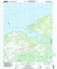
1998 Map of Columbia West
USGS Topo · Published 2001About this map
The Scuppernong River winds through the lowlands of Tyrrell County toward the broad waters of Albemarle Sound and Bull Bay. This coastal landscape is defined by its relationship with the water, as evidenced by numerous historic river access points such as Back Landing, River Neck Landing, and Simmons Landing. The settlement of Columbia sits at a critical crossing on the river's eastern bank, serving as a hub for the surrounding rural communities of Travis and Woodley.
Find a feature on this map
24 named features on this map. Tap any name to fly to it.
Don’t see what you’re looking for? This feature index may not catch every label — zoom into the map to look around manually.
Map Details
Editions of this 1998 Columbia West Map
This is the sole edition of this map. No revisions or reprints were ever made.
Other maps of this area

1906 · Hertford
USGS Topo · 1:62,500

1940 · Hertford
USGS Topo · 1:62,500

1940 · Wade Point
USGS Topo · 1:62,500

1943 · Wade Point
USGS Topo · 1:62,500

1943 · Columbia
USGS Topo · 1:125,000

1948 · Wade Point
USGS Topo · 1:62,500

1953 · Norfolk
USGS Topo · 1:250,000

1953 · Columbia East
USGS Topo · 1:24,000

1953 · Scotia
USGS Topo · 1:24,000

1953 · Columbia West
USGS Topo · 1:24,000