
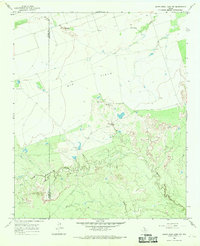
1966 Map of Colwell Creek
USGS Topo · Published 1969About this map
The North Wichita River meanders across this mid-1960s landscape, defining the jagged boundary between Foard and Knox counties. The terrain is characterized by the deeply dissected breaks of the Rolling Plains, where the river's path is carved through a series of dramatic bends. To the south, the topography rises sharply toward Ignorant Ridge, a prominent landform overlooking the Colwell Creek drainage.
Find a feature on this map
11 named features on this map. Tap any name to fly to it.
Don’t see what you’re looking for? This feature index may not catch every label — zoom into the map to look around manually.
Map Details
Editions of this 1966 Colwell Creek Map
This is the sole edition of this map. No revisions or reprints were ever made.
Other maps of this area

1954 · Wichita Falls
USGS Topo · 1:250,000

1958 · Wichita Falls
USGS Topo · 1:250,000

1966 · Santa Rosa Lake SW
USGS Topo · 1:24,000

1966 · Soap Creek
USGS Topo · 1:24,000

1966 · Halsell Ranch
USGS Topo · 1:24,000

1966 · Gilliland
USGS Topo · 1:24,000

1966 · Crowell
USGS Topo · 1:24,000

1966 · Vera
USGS Topo · 1:24,000

1966 · Thalia
USGS Topo · 1:24,000
1966 · Santa Rosa Lake NW
USGS Topo · 1:24,000