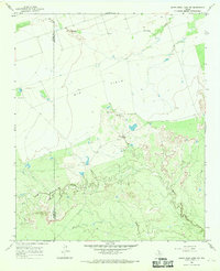
1966 Map of Santa Rosa Lake NW
USGS Topo · Published 1969About this map
The rolling plains of the Texas Panhandle transition into a landscape shaped by ranching and resource extraction in this mid-1960s survey. Spanning the county line between Foard Co Wilbarger Co, the map highlights the utilitarian nature of the region through markers like Slay Camp and Hart Camp. The northern portion is dominated by the expansive Big Field, while the southern reaches are defined by the winding course of Beaver Creek. The presence of Iron Pens and Grain Elevators underscores the agricultural economy, providing specific points of interest for those researching the rural industrial footprint of North Texas. Drainage patterns are anchored by Paradise Creek, which carves through the northern terrain, and a lonely Gravel Pit indicates the localized quarrying activity essential for area infrastructure.
Find a feature on this map
9 named features on this map. Tap any name to fly to it.
Don’t see what you’re looking for? This feature index may not catch every label — zoom into the map to look around manually.
Map Details
Editions of this 1966 Santa Rosa Lake NW Map
This is the sole edition of this map. No revisions or reprints were ever made.
Other maps of this area

1954 · Wichita Falls
USGS Topo · 1:250,000

1955 · Lawton
USGS Topo · 1:250,000

1958 · Wichita Falls
USGS Topo · 1:250,000

1958 · Vernon
USGS Topo · 1:62,500

1958 · Medicine Mound
USGS Topo · 1:62,500

1966 · Santa Rosa Lake
USGS Topo · 1:24,000

1966 · Santa Rosa Lake SW
USGS Topo · 1:24,000

1966 · Colwell Creek
USGS Topo · 1:24,000

1966 · Northwest Lake Kemp
USGS Topo · 1:24,000

1966 · Thalia
USGS Topo · 1:24,000