
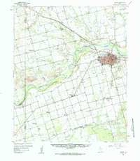
1958 Map of Vernon
USGS Topo · Published 1959About this map
The Pease River meanders across this North Texas landscape, defining the transition between the agricultural plains of Lockett and the industrial hub of Vernon. In the late 1950s, the city of Vernon serves as a focal point for the region's transport and culture, anchored by the Santa Rosa Roundup Rodeo Grounds and the sprawling campus of the Vernon State Hospital. The influence of the railroad is evident in the path of the Fort Worth and Denver, which links smaller communities like Tolbert to the larger market. Rural life is well-documented through a network of local institutions, including Pleasant Home Ch and Zion Ch Cem, which are surrounded by the agricultural reaches of Farmers Valley. This survey captures the county's mid-century development, from the Hillcrest Country Club to the various Gravel Pits that supported local infrastructure.
Find a feature on this map
39 named features on this map. Tap any name to fly to it.
Don’t see what you’re looking for? This feature index may not catch every label — zoom into the map to look around manually.
Map Details
Editions of this 1958 Vernon Map
2 editions found
Other maps of this area

1954 · Wichita Falls
USGS Topo · 1:250,000

1955 · Lawton
USGS Topo · 1:250,000

1958 · Wichita Falls
USGS Topo · 1:250,000

1958 · Davidson
USGS Topo · 1:62,500

1958 · Frederick
USGS Topo · 1:62,500

1958 · Medicine Mound
USGS Topo · 1:62,500

1958 · Elmer
USGS Topo · 1:62,500

1960 · Quanah
USGS Topo · 1:62,500

1966 · Santa Rosa Lake
USGS Topo · 1:24,000

1966 · Grayback
USGS Topo · 1:24,000