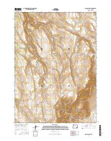
2017 Map of Comegys Lake
USGS Topo · Published 2017About this map
Steens Mtn dominates the eastern high desert of Harney County, Oregon, where this survey documents a landscape of vital water sources and vast elevation changes. Named landmarks often reveal the family histories of the region, such as Ross Dollarhide Springs, Bill Gordon Spring, and Charles Kuhl Springs, which provide critical reference points in an area defined by dry ridges and seasonal drainages. The topography transitions from the high peaks of Bald Mtn down into Stonehouse Canyon, while the presence of Comegys Lake and Dollar Lake highlights the importance of localized catchments in this arid environment. Transportation is limited to the peripheral Fields-Denio Rd, underscoring the remoteness of the central basin and the Puhi-Pane Na-De Flat. The map provides a precise account of the Public Land Survey System divisions, from t30s r34e to t31s r35e.
Find a feature on this map
24 named features on this map. Tap any name to fly to it.
Don’t see what you’re looking for? This feature index may not catch every label — zoom into the map to look around manually.
Map Details
Editions of this 2017 Comegys Lake Map
This is the sole edition of this map. No revisions or reprints were ever made.
Other maps of this area

1955 · Burns
USGS Topo · 1:250,000

1955 · Adel
USGS Topo · 1:250,000

1957 · Adel
USGS Topo · 1:250,000

1958 · Burns
USGS Topo · 1:250,000

1958 · Adel
USGS Topo · 1:250,000

1959 · Burns
USGS Topo · 1:250,000

1962 · Adel
USGS Topo · 1:250,000

1967 · Happy Valley
USGS Topo · 1:24,000

1968 · Poison Springs
USGS Topo · 1:24,000

1968 · Big Pasture Creek
USGS Topo · 1:24,000