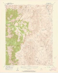
1957 Map of Como
USGS Topo · Published 1958About this map
Pine Nut Mountains dominate the western portion of this 1957 survey, where the mining settlement of Como is surrounded by a network of prospects and shafts. The landscape is defined by its industrial activity and water management in a high-desert environment, evidenced by the Hercules Mine to the north and the Guild Placer Mines near the eastern edge. Settlement patterns follow the rugged topography, with Sunrise Camp and the JW Ranch providing rare points of habitation between the high peaks and the basins. Significant elevation changes are marked by landmarks like Mount Como and Rawe Peak, while the movement of water is tracked through features like the Adrian Valley Ditch and numerous isolated springs such as Willow Spring. The eastern margin of the sheet captures the edge of the Singatse Range, showing a transition from mining-heavy mountain terrain toward the flatter expanses of Lincoln Flat and Mason Valley.
Find a feature on this map
40 named features on this map. Tap any name to fly to it.
Don’t see what you’re looking for? This feature index may not catch every label — zoom into the map to look around manually.
Map Details
Editions of this 1957 Como Map
3 editions found

Other maps of this area

1889 · Markleeville
USGS Topo · 1:125,000

1891 · Carson
USGS Topo · 1:125,000

1891 · Markleeville
USGS Topo · 1:125,000

1891 · Wabuska
USGS Topo · 1:125,000

1891 · Wellington
USGS Topo · 1:125,000

1893 · Carson
USGS Topo · 1:125,000

1893 · Markleeville
USGS Topo · 1:125,000

1893 · Wellington
USGS Topo · 1:125,000

1894 · Wabuska
USGS Topo · 1:125,000

1948 · Walker Lake
USGS Topo · 1:250,000