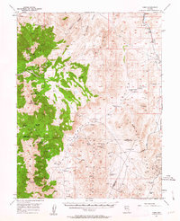
1957 Map of Como
USGS Topo · Published 1963About this map
Mining operations and high-desert ranching define this mid-century view of the western Nevada landscape. The settlement of Como sits high in the Pine Nut Mountains, surrounded by evidence of early industrial activity including the Boyle Tunnel, Hercules Mine, and several unnamed shafts. To the east, the terrain descends into Lincoln Flat and the Singatse Range, where the labor of water reclamation is visible through features like Sario Well and the series of Fulstone No 1 Spring locations.
Find a feature on this map
44 named features on this map. Tap any name to fly to it.
Don’t see what you’re looking for? This feature index may not catch every label — zoom into the map to look around manually.
Map Details
Editions of this 1957 Como Map
3 editions found

Other maps of this area

1889 · Markleeville
USGS Topo · 1:125,000

1891 · Carson
USGS Topo · 1:125,000

1891 · Markleeville
USGS Topo · 1:125,000

1891 · Wabuska
USGS Topo · 1:125,000

1891 · Wellington
USGS Topo · 1:125,000

1893 · Carson
USGS Topo · 1:125,000

1893 · Markleeville
USGS Topo · 1:125,000

1893 · Wellington
USGS Topo · 1:125,000

1894 · Wabuska
USGS Topo · 1:125,000

1948 · Walker Lake
USGS Topo · 1:250,000