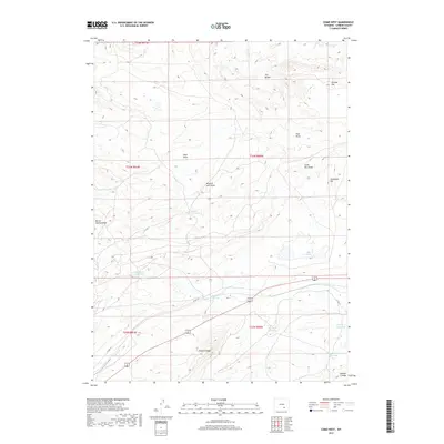
2017 Map of Como West
USGS Topo · Published 2017About this map
Hi Allen Ridge and the surrounding drainage network of the Laramie Plains define this high-desert landscape in Carbon County. The terrain is deeply incised by seasonal watercourses and topographic lows, including Dixie Draw, Missouri John Draw, and Barrel Springs Draw. Human interaction with this arid environment is most evident in the complex system of water management features, ranging from the Big Ditch to several named catchments such as Rosebud Reservoir, Big Rock Reservoir, and Number 5 Reservoir. These reservoirs and springs, including Missouri John Spring and Hi Allen Spring, represent critical infrastructure for ranching and resource management in a region where water sources dictate movement and settlement patterns. Landmarks like Wildcat Top and Sevenmile Hill serve as significant navigational anchors across the open expanse.
Find a feature on this map
25 named features on this map. Tap any name to fly to it.
Don’t see what you’re looking for? This feature index may not catch every label — zoom into the map to look around manually.
Map Details
Editions of this 2017 Como West Map
This is the sole edition of this map. No revisions or reprints were ever made.
Other maps of this area

1893 · Fort Steele
USGS Topo · 1:125,000

1914 · Hanna
USGS Topo · 1:62,500

1914 · Saddleback Hills
USGS Topo · 1:62,500

1921 · Saddleback Hills
USGS Topo · 1:62,500

1953 · T E Ranch
USGS Topo · 1:24,000

1954 · Rawlins
USGS Topo · 1:250,000

1955 · Casper
USGS Topo · 1:250,000

1958 · Rawlins
USGS Topo · 1:250,000

1958 · Casper
USGS Topo · 1:250,000
1961 · Windy Hill
USGS Topo · 1:24,000