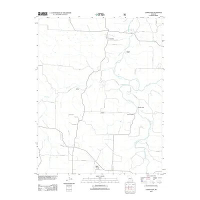
2012 Map of Competition
USGS Topo · Published 2012About this map
Competition and the rural surroundings of Wright County are defined by the winding course of the Gasconade River as it passes through Wichita Hollow and past the crossing at Burney Ford. This 2012 topographic record details a landscape of narrow hollows and ridge-top roads, reflecting a long history of upland farming and river-valley settlement. The small community of Jerktail sits centrally, connected by local routes like Jerktail Rd and New Home Rd to southern points like Saint George.
Find a feature on this map
41 named features on this map. Tap any name to fly to it.
Don’t see what you’re looking for? This feature index may not catch every label — zoom into the map to look around manually.
Map Details
Editions of this 2012 Competition Map
This is the sole edition of this map. No revisions or reprints were ever made.
Other maps of this area

1931 · Manes
USGS Topo · 1:48,000

1941 · Manes
USGS Topo · 1:62,500

1941 · Lebanon
USGS Topo · 1:62,500

1943 · Lebanon
USGS Topo · 1:62,500

1943 · Manes
USGS Topo · 1:62,500

1943 · Drynob
USGS Topo · 1:62,500

1954 · Springfield
USGS Topo · 1:250,000

1954 · Drynob
USGS Topo · 1:62,500

1954 · Drew
USGS Topo · 1:24,000
1954 · Winnipeg
USGS Topo · 1:24,000