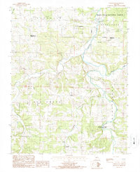
1987 Map of Competition
USGS Topo · Published 1987About this map
The Gasconade River meanders through this portion of the Ozarks, defining the eastern landscape where it flows past the Wilber Allen Memorial State Wildlife Area. This mid-1980s topography reveals a rural network of small settlements and named hollows straddling the Laclede and Wright County line. The community of Competition sits in the north near the Mark Twain National Forest boundary, while smaller locales like Jerktail and St George are found further south along the winding course of Elk Creek. The map documents a rugged interior terrain where local life is organized around deep drainages like Wichita Hollow and Hillhouse Hollow. Scattered cemeteries and remote road crossings provide essential landmarks for genealogists and local historians tracing family holdings in this corner of Missouri.
Find a feature on this map
15 named features on this map. Tap any name to fly to it.
Don’t see what you’re looking for? This feature index may not catch every label — zoom into the map to look around manually.
Map Details
Editions of this 1987 Competition Map
This is the sole edition of this map. No revisions or reprints were ever made.
Other maps of this area

1931 · Manes
USGS Topo · 1:48,000

1941 · Manes
USGS Topo · 1:62,500

1941 · Lebanon
USGS Topo · 1:62,500

1943 · Lebanon
USGS Topo · 1:62,500

1943 · Manes
USGS Topo · 1:62,500

1943 · Drynob
USGS Topo · 1:62,500

1954 · Springfield
USGS Topo · 1:250,000

1954 · Drynob
USGS Topo · 1:62,500

1954 · Drew
USGS Topo · 1:24,000
1954 · Winnipeg
USGS Topo · 1:24,000