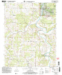
2004 Map of Competition
USGS Topo · Published 2006About this map
Competition and St George serve as the primary focal points of this Ozark landscape, which is defined by the winding course of the Gasconade River. The river forms a natural corridor through the eastern portion of the map, carving deep valleys and supporting the Wilbur Allen Conservation Area. This region is characterized by a complex network of waterways, including Elk Creek, Beaver Creek, and Webb Creek, which drain the surrounding plateaus. The rugged geography is further evidenced by several named drainages such as Wichita Hollow, Sand Hollow, and Hillhouse Hollow.
Find a feature on this map
24 named features on this map. Tap any name to fly to it.
Don’t see what you’re looking for? This feature index may not catch every label — zoom into the map to look around manually.
Map Details
Editions of this 2004 Competition Map
This is the sole edition of this map. No revisions or reprints were ever made.
Other maps of this area

1931 · Manes
USGS Topo · 1:48,000

1941 · Manes
USGS Topo · 1:62,500

1941 · Lebanon
USGS Topo · 1:62,500

1943 · Lebanon
USGS Topo · 1:62,500

1943 · Manes
USGS Topo · 1:62,500

1943 · Drynob
USGS Topo · 1:62,500

1954 · Springfield
USGS Topo · 1:250,000

1954 · Drynob
USGS Topo · 1:62,500

1954 · Drew
USGS Topo · 1:24,000
1954 · Winnipeg
USGS Topo · 1:24,000