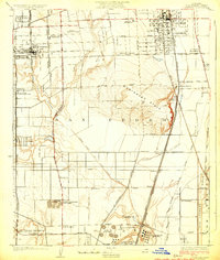
1924 Map of Compton
USGS Topo · Published 1924About this map
The Dominguez Hills rise above a landscape of transitioning land use, where agricultural tracts meet the burgeoning oil industry of Southern California. Centered on the city of Compton, this 1923 survey documents a network of small settlements and educational institutions like the Gardens Japanese School and the McKinley Industrial Home. The presence of the Spanish American Institute and the Compton Sanitarium reflects the specialized social and medical facilities established here during the early twentieth century.
Find a feature on this map
60 named features on this map. Tap any name to fly to it.
Don’t see what you’re looking for? This feature index may not catch every label — zoom into the map to look around manually.
Map Details
Editions of this 1924 Compton Map
This is the sole edition of this map. No revisions or reprints were ever made.
Other maps of this area

1896 · Redondo
USGS Topo · 1:62,500

1896 · Downey
USGS Topo · 1:62,500

1899 · Downey
USGS Topo · 1:62,500

1901 · Southern California Sheet No. 1
USGS Topo · 1:250,000

1902 · Downey
USGS Topo · 1:62,500

1904 · Southern California Sheet No. 1
USGS Topo · 1:250,000
1923 · Bell
USGS Topo · 1:24,000

1923 · Wilmington
USGS Topo · 1:24,000
1923 · Watts
USGS Topo · 1:24,000
1924 · Inglewood
USGS Topo · 1:24,000