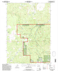
1992 Map of Conant Basin
USGS Topo · Published 1997About this map
Maury Mountains dominate this high-desert landscape in central Oregon, where the Ochoco National Forest boundary meets extensive ranchlands. The map documents a rugged interior geography defined by the Conant Basin and a network of ephemeral water sources, including Colby Spring, Sanford Spring, and Swamp Spring. Settlement patterns in the early 1990s remained centered on established livestock operations, with Kizer Ranch and Bolletto Ranch situated near the northern drainages, while Adams Ranch and Nye Ranch occupy the southern basins. A notable Quarry near Newsome Saddle indicates local resource extraction amidst the complex terrain of Sheep Rock and Coyote Butte. The detailed hydrography of Sanford Creek and Gibson Creek illustrates the vital role of seasonal water in sustaining these remote agricultural outposts.
Find a feature on this map
36 named features on this map. Tap any name to fly to it.
Don’t see what you’re looking for? This feature index may not catch every label — zoom into the map to look around manually.
Map Details
Editions of this 1992 Conant Basin Map
This is the sole edition of this map. No revisions or reprints were ever made.
Other maps of this area

1946 · Eagle Rock
USGS Topo · 1:62,500

1948 · Eagle Rock
USGS Topo · 1:62,500

1951 · Post
USGS Topo · 1:62,500

1955 · Crescent
USGS Topo · 1:250,000

1955 · Bend
USGS Topo · 1:250,000

1957 · Crescent
USGS Topo · 1:250,000

1957 · Bend
USGS Topo · 1:250,000

1958 · Crescent
USGS Topo · 1:250,000

1958 · Bend
USGS Topo · 1:250,000

1967 · Brothers NW
USGS Topo · 1:24,000