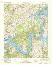
1968 Map of Concord
USGS Topo · Published 1972About this map
Fort Loudoun Dam anchors this late-1960s landscape, where the Tennessee River expands into the wide reaches of Fort Loudoun Lake. The map captures a pivotal moment for the local hydrography, specifically noting that Tellico Lake was then a project with its dam under construction. This intersection of major waterways is surrounded by established settlements like Concord and Friendsville, alongside newer developments such as Scenic Point Estates and Fort Loudoun Estates.
Find a feature on this map
100 named features on this map. Tap any name to fly to it.
Don’t see what you’re looking for? This feature index may not catch every label — zoom into the map to look around manually.
Map Details
Editions of this 1968 Concord Map
2 editions found
Other maps of this area

1895 · Loudon
USGS Topo · 1:125,000

1935 · Binfield
USGS Topo · 1:24,000

1935 · Meadow
USGS Topo · 1:24,000

1935 · Lenoir City
USGS Topo · 1:24,000

1935 · Bethel Valley
USGS Topo · 1:24,000

1935 · Bearden
USGS Topo · 1:24,000

1935 · Lovell
USGS Topo · 1:24,000

1936 · Louisville
USGS Topo · 1:24,000

1936 · Friendship
USGS Topo · 1:48,000

1936 · Loudon
USGS Topo · 1:24,000