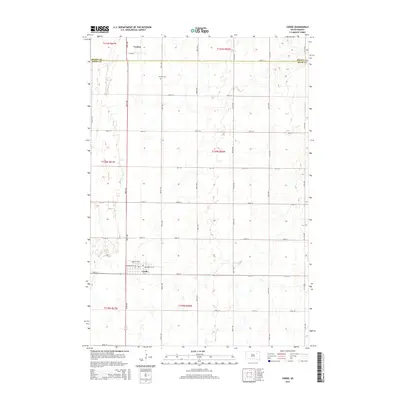
2015 Map of Conde
USGS Topo · Published 2015About this map
Conde and the surrounding prairie of northeastern South Dakota are defined by a regular grid of section lines and township boundaries in this 2015 survey. The town of Conde serves as a local hub, situated at the junction of 154th St and Cr-6, featuring a residential street plan including Maple St NW and Broadway St NE. To the north, the small settlement of Verdon sits near the border of Brown Co and Spink Co. This map provides clear documentation of the rural landscape and local infrastructure, including the Verdon Cem located along 407th Ave, offering a detailed record of land divisions and road networks across t120n r60w and adjacent townships.
Find a feature on this map
24 named features on this map. Tap any name to fly to it.
Don’t see what you’re looking for? This feature index may not catch every label — zoom into the map to look around manually.
Map Details
Editions of this 2015 Conde Map
This is the sole edition of this map. No revisions or reprints were ever made.
Other maps of this area

1894 · Conde
USGS Topo · 1:62,500

1895 · Aberdeen
USGS Topo · 1:125,000

1953 · Groton SW
USGS Topo · 1:24,000

1953 · Milbank
USGS Topo · 1:250,000

1954 · Ferney
USGS Topo · 1:24,000

1954 · Aberdeen
USGS Topo · 1:250,000

1956 · Aberdeen
USGS Topo · 1:250,000

1958 · Milbank
USGS Topo · 1:250,000
1958 · Randolph
USGS Topo · 1:24,000
1958 · Conde
USGS Topo · 1:24,000