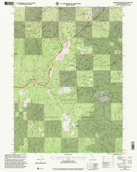
1998 Map of Condrey Mountain
USGS Topo · Published 2001About this map
The Siskiyou Mountains define this high-elevation terrain along the border of the Klamath National Forest and Rogue River National Forest. At the center of the survey is Condrey Mountain, a prominent peak surrounded by a network of springs and gulches that feed into Elliott Creek and Donomore Creek. The landscape is a study in resource extraction and recreation, featuring the historic Cinnabar Mine and Penn Mine alongside the winding path of the Pacific Crest National Scenic Trail.
Find a feature on this map
45 named features on this map. Tap any name to fly to it.
Don’t see what you’re looking for? This feature index may not catch every label — zoom into the map to look around manually.
Map Details
Editions of this 1998 Condrey Mountain Map
This is the sole edition of this map. No revisions or reprints were ever made.
Other maps of this area

1886 · Shasta
USGS Topo · 1:250,000

1891 · Ashland
USGS Topo · 1:250,000

1893 · Ashland
USGS Topo · 1:250,000

1894 · Shasta
USGS Topo · 1:250,000

1897 · Ashland
USGS Topo · 1:250,000

1908 · Grants Pass
USGS Topo · 1:125,000

1914 · Seiad
USGS Topo · 1:125,000

1922 · Seiad
USGS Topo · 1:125,000

1932 · Yreka
USGS Topo · 1:96,000

1938 · Medford
USGS Topo · 1:125,000