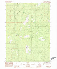
1983 Map of Condrey Mtn
USGS Topo · Published 1984About this map
Siskiyou Mountains terrain defines this high-elevation boundary region between the Klamath National Forest and Rogue River National Forest. The landscape is a network of ridges and drainage basins, most notably the Middle Fork Rogue River and its various tributaries like Pack Creek and Donomore Creek. Geologic interest is evident in the presence of the Elliott Mine and Cinnabar Mine, alongside the Big Rock Prospects, reflecting the area's history of mineral exploration. Transport through this difficult terrain in the early 1980s was limited to routes like Studhorse Trail and the winding Doggett Creek Road. Named landmarks such as Condrey Mtn and Dry Lake Mtn provide essential orientation points for understanding the natural geography of this northern California wilderness before the turn of the century.
Find a feature on this map
47 named features on this map. Tap any name to fly to it.
Don’t see what you’re looking for? This feature index may not catch every label — zoom into the map to look around manually.
Map Details
Editions of this 1983 Condrey Mtn Map
This is the sole edition of this map. No revisions or reprints were ever made.
Other maps of this area

1886 · Shasta
USGS Topo · 1:250,000

1891 · Ashland
USGS Topo · 1:250,000

1893 · Ashland
USGS Topo · 1:250,000

1894 · Shasta
USGS Topo · 1:250,000

1897 · Ashland
USGS Topo · 1:250,000

1908 · Grants Pass
USGS Topo · 1:125,000

1914 · Seiad
USGS Topo · 1:125,000

1922 · Seiad
USGS Topo · 1:125,000

1932 · Yreka
USGS Topo · 1:96,000

1938 · Medford
USGS Topo · 1:125,000