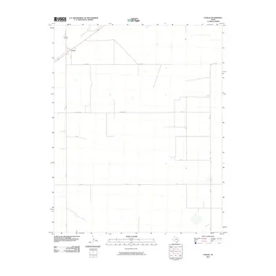
2010 Map of Conlen
USGS Topo · Published 2010About this map
Conlen serves as the primary hub of this high plains landscape in the Texas Panhandle, positioned along the intersection of Highway 54 and FM 807. The town's layout is closely tied to the transport corridor, with the nearby Conlen Airport supporting the region's agricultural and logistical needs. The surrounding terrain is defined by a strictly organized grid of local roads with evocative names like Cedar Post Ln, Seed Ln, and 3f Ln. These labels reflect the ranching and farming heritage of Dallam County, where large parcels of land are divided by straight-line routes such as Conlen Ln and Jake Rd. The map illustrates a sparse, functional settlement pattern characteristic of the region, where infrastructure is designed to bridge the significant distances between individual farmsteads and the central rail and road junction at Conlen.
Find a feature on this map
14 named features on this map. Tap any name to fly to it.
Don’t see what you’re looking for? This feature index may not catch every label — zoom into the map to look around manually.
Map Details
Editions of this 2010 Conlen Map
This is the sole edition of this map. No revisions or reprints were ever made.
Other maps of this area

1954 · Dalhart
USGS Topo · 1:250,000

1958 · Dalhart
USGS Topo · 1:250,000

1962 · Dalhart
USGS Topo · 1:250,000

1964 · Brickel
USGS Topo · 1:24,000

1964 · Stratford 2 SE
USGS Topo · 1:24,000

1964 · Stratford
USGS Topo · 1:24,000

1965 · Wilco
USGS Topo · 1:24,000

1965 · Lautz
USGS Topo · 1:24,000

1965 · Conlen
USGS Topo · 1:24,000
1965 · Cactus West
USGS Topo · 1:24,000