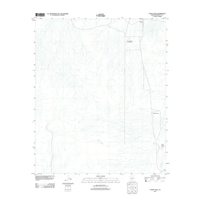
2011 Map of Conley Well
USGS Topo · Published 2011About this map
Waterman Wash and Vekol Wash dominate this desert landscape in southern Maricopa County, highlighting the complex drainage patterns that define the region. The map reveals a specific aviation-oriented settlement pattern where private airstrips and small-scale ranching operations dot the arid plains. These include Flying Bucket Ranch Airport and Walter Ranch Airport, alongside the central Conley Well. The presence of Serene Field and Motown Airport suggests a specialized land use for flight activity far from the dense urban centers of the Valley of the Sun. Local access is managed through isolated thoroughfares like S 107th Ave and 91st Ave, which provide the primary connectivity for the scattered residents at the A K Ranch and surrounding properties.
Find a feature on this map
11 named features on this map. Tap any name to fly to it.
Don’t see what you’re looking for? This feature index may not catch every label — zoom into the map to look around manually.
Map Details
Editions of this 2011 Conley Well Map
This is the sole edition of this map. No revisions or reprints were ever made.
Other maps of this area

1913 · Maricopa
USGS Topo · 1:62,500

1915 · Maricopa
USGS Topo · 1:62,500

1946 · Antelope Peak
USGS Topo · 1:62,500

1948 · Antelope Peak
USGS Topo · 1:62,500

1951 · Estrella
USGS Topo · 1:62,500

1951 · Mobile
USGS Topo · 1:62,500

1952 · Enid
USGS Topo · 1:24,000
1952 · Maricopa
USGS Topo · 1:62,500

1953 · Ajo
USGS Topo · 1:250,000

1954 · Phoenix
USGS Topo · 1:250,000