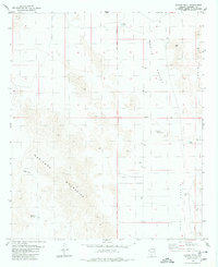
1979 Map of Conley Well
USGS Topo · Published 1980About this map
The Maricopa Mountains dominate this arid landscape on the edge of the Gila and Salt River Meridian, showing the delicate balance of ranching and water management in the late 1970s. Ranching infrastructure is central to the area's layout, anchored by the A K Ranch and vital water sources like Conley Well and the Big Horn Reservoir. The map reveals how the desert was utilized for livestock, with various catchments such as Little Bruce Tank and Big Tank distributed across the Vekol Valley and Mobile Valley. Notable human history is present in the form of unidentified Ruins in the northeast and a Gravel Pit near the mountain base, providing a look at local resource extraction and early habitation patterns before further modernization reached this part of the county.
Find a feature on this map
15 named features on this map. Tap any name to fly to it.
Don’t see what you’re looking for? This feature index may not catch every label — zoom into the map to look around manually.
Map Details
Editions of this 1979 Conley Well Map
This is the sole edition of this map. No revisions or reprints were ever made.
Other maps of this area

1913 · Maricopa
USGS Topo · 1:62,500

1915 · Maricopa
USGS Topo · 1:62,500

1946 · Antelope Peak
USGS Topo · 1:62,500

1948 · Antelope Peak
USGS Topo · 1:62,500

1951 · Estrella
USGS Topo · 1:62,500

1951 · Mobile
USGS Topo · 1:62,500

1952 · Enid
USGS Topo · 1:24,000
1952 · Maricopa
USGS Topo · 1:62,500

1953 · Ajo
USGS Topo · 1:250,000

1954 · Phoenix
USGS Topo · 1:250,000