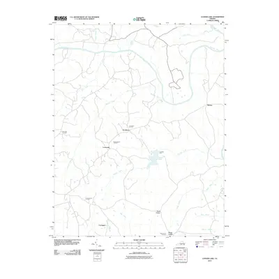
2010 Map of Conner Lake
USGS Topo · Published 2010About this map
The Roanoke River snakes across the northern landscape of this region, joined by a dense network of tributaries including Turnip Creek, Ellis Creek, and Buckskin Creek. This part of Halifax County is defined by its small crossroads settlements and family burial grounds that anchor the local geography. Small communities such as Providence, Crossroads, and Neals Corner are connected by a web of rural roads, while Carrington and Mount Laurel mark the southern reaches of the map. Central to the area is Conner Lake, regulated by Conners Dam and fed by Hunting Creek. For those tracing local heritage, several established burial sites are documented, including the Providence Cemetery, Mount Pleasant Cemetery, and the Huntingcreek Cemetery near the western edge of the quadrangle. The hydrology of the area is complex, with numerous branches like Race Branch and Martins Branch draining into the larger creek systems.
Find a feature on this map
25 named features on this map. Tap any name to fly to it.
Don’t see what you’re looking for? This feature index may not catch every label — zoom into the map to look around manually.
Map Details
Editions of this 2010 Conner Lake Map
This is the sole edition of this map. No revisions or reprints were ever made.
Other maps of this area

1892 · Appomattox
USGS Topo · 1:125,000

1947 · Roanoke
USGS Topo · 1:250,000

1953 · Greensboro
USGS Topo · 1:250,000

1954 · Greensboro
USGS Topo · 1:250,000

1954 · Clover
USGS Topo · 1:62,500

1954 · Halifax
USGS Topo · 1:62,500

1956 · Brookneal
USGS Topo · 1:62,500

1956 · Charlotte Court House
USGS Topo · 1:62,500

1959 · Roanoke
USGS Topo · 1:250,000

1962 · Greensboro
USGS Topo · 1:250,000