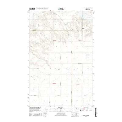
2014 Map of Conrad Butte
USGS Topo · Published 2014About this map
Conrad Butte rises from the prairie of Pondera County in this 2014 survey, a prominent landmark in a landscape defined by expansive benchlands and coulees. The map traces the winding course of the Marias River and the Dry Fork Marias River as they cut through the northern portion of the quadrangle. This area, straddling the border with Toole County, illustrates a well-organized rural infrastructure of named access routes like Reclamation Rd and Union School Rd, serving the agricultural reaches of Atkinson Flat and Tank Flat. Cultural history is encoded in the local nomenclature, most notably the Whoop Up Trl, a route deeply connected to the 19th-century trade networks between Fort Benton and Fort Whoop-Up. Water management for the high plains is evident through features such as the Jim Judisch Reservoir and M Ratzburg Reservoir.
Find a feature on this map
24 named features on this map. Tap any name to fly to it.
Don’t see what you’re looking for? This feature index may not catch every label — zoom into the map to look around manually.
Map Details
Editions of this 2014 Conrad Butte Map
This is the sole edition of this map. No revisions or reprints were ever made.
Other maps of this area

1920 · Conrad
USGS Topo · 1:125,000

1954 · Shelby
USGS Topo · 1:250,000

1958 · Shelby
USGS Topo · 1:250,000

1967 · Central School
USGS Topo · 1:24,000

1967 · Naismith
USGS Topo · 1:24,000

1967 · Conrad Butte
USGS Topo · 1:24,000

1967 · South Devon School
USGS Topo · 1:24,000

1967 · Dunkirk
USGS Topo · 1:24,000

1967 · Fowler Coulee NW
USGS Topo · 1:24,000
1967 · Letz Lake
USGS Topo · 1:24,000