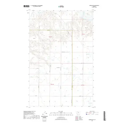
2020 Map of Conrad Butte
USGS Topo · Published 2020About this map
Conrad Butte stands as a prominent landmark in this section of the High Plains, where the northern Montana landscape is defined by the winding course of the Marias River and its tributary, the Dry Fork Marias River. The terrain features expansive plateaus like Atkinson Flat and Tank Flat, broken by the intricate coulees and drainage patterns typical of this semi-arid region. Settlement is characterized by a regular grid of section-line roads, including Ledger Rd and Union School Rd, which serve the agricultural interests of the area. Human modification of the water system is evident through irrigation and storage features such as the Jim Judisch Reservoir and M Ratzburg Reservoir. Of particular interest to local historians is the Whoop Up Trl, a historic freight route that once connected the Missouri River to the Canadian northwest.
Find a feature on this map
26 named features on this map. Tap any name to fly to it.
Don’t see what you’re looking for? This feature index may not catch every label — zoom into the map to look around manually.
Map Details
Editions of this 2020 Conrad Butte Map
This is the sole edition of this map. No revisions or reprints were ever made.
Other maps of this area

1920 · Conrad
USGS Topo · 1:125,000

1954 · Shelby
USGS Topo · 1:250,000

1958 · Shelby
USGS Topo · 1:250,000

1967 · Central School
USGS Topo · 1:24,000

1967 · Naismith
USGS Topo · 1:24,000

1967 · Conrad Butte
USGS Topo · 1:24,000

1967 · South Devon School
USGS Topo · 1:24,000

1967 · Dunkirk
USGS Topo · 1:24,000

1967 · Fowler Coulee NW
USGS Topo · 1:24,000
1967 · Letz Lake
USGS Topo · 1:24,000