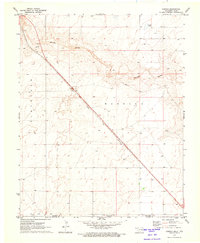
1971 Map of Conrad
USGS Topo · Published 1973About this map
Conrad and the surrounding high plains of the Oklahoma Panhandle are defined here by the transit corridor of the Atchison Topeka and Santa Fe railroad. This 1971 survey captures the landscape just north of the Texas border, where the Beaver River winds through the northern reaches of the quadrangle. The terrain transitions from the river's drainage to the broad flats of Marella, a region punctuated by small depressions and water features like Ritner Lake. Economic activity is represented by localized industry, such as a Caliche Pit near the rail line, while the map clearly delineates the geopolitical boundary between Cimarron County and Dallam County at the Oklahoma-Texas state line. The survey reflects a sparsely populated ranching and agricultural district during a period of established rail transport and rural land management.
Find a feature on this map
8 named features on this map. Tap any name to fly to it.
Don’t see what you’re looking for? This feature index may not catch every label — zoom into the map to look around manually.
Map Details
Editions of this 1971 Conrad Map
This is the sole edition of this map. No revisions or reprints were ever made.
Other maps of this area

1954 · Dalhart
USGS Topo · 1:250,000

1958 · Dalhart
USGS Topo · 1:250,000

1962 · Dalhart
USGS Topo · 1:250,000

1964 · Kerrick
USGS Topo · 1:24,000

1964 · Stratford 2 NE
USGS Topo · 1:24,000

1971 · Griggs SW
USGS Topo · 1:24,000

1971 · Sampsel Lake
USGS Topo · 1:24,000

1971 · Conrad NW
USGS Topo · 1:24,000

1971 · Griggs NW
USGS Topo · 1:24,000

1971 · Conrad SW
USGS Topo · 1:24,000