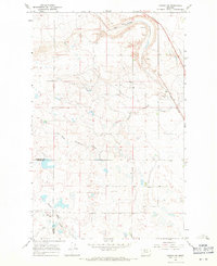
1967 Map of Conrad SW
USGS Topo · Published 1971About this map
The rolling prairies of the Montana high plains are defined here by the winding course of South Pondera Coulee and the adjacent seasonal drainage of Kropp Coulee. This 1960s landscape showcases the intersection of hydraulic geography and industrial transit, with the Great Northern railroad cutting through the northeastern corner of the map. The rail line is flanked by several Gravel Pit sites, signaling the infrastructure needs of the era. To the south, the Eyraud Lakes occupy a lower basin, while the boundary between Pondera Co and Teton Co crosses the terrain. The map is a study in prairie hydrology and the sparse but vital transport networks that supported the region's ranching and industrial interests during the mid-twentieth century.
Find a feature on this map
7 named features on this map. Tap any name to fly to it.
Don’t see what you’re looking for? This feature index may not catch every label — zoom into the map to look around manually.
Map Details
Editions of this 1967 Conrad SW Map
This is the sole edition of this map. No revisions or reprints were ever made.
Other maps of this area

1886 · Great Falls
USGS Topo · 1:250,000

1920 · Choteau
USGS Topo · 1:125,000

1920 · Dupuyer
USGS Topo · 1:125,000

1920 · Conrad
USGS Topo · 1:125,000

1938 · Gallup City
USGS Topo · 1:62,500

1942 · Gallup City
USGS Topo · 1:62,500

1950 · Collins
USGS Topo · 1:62,500

1954 · Great Falls
USGS Topo · 1:250,000

1954 · Shelby
USGS Topo · 1:250,000

1955 · Choteau
USGS Topo · 1:250,000