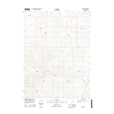
2014 Map of Contact
USGS Topo · Published 2014About this map
Contact is the primary settlement on this northeastern Nevada quadrangle, situated along the banks of Salmon Falls Cr. This area is characterized by the prominent peaks and drainages of the Salmon River Range, where high-elevation landmarks like Ellen D Mtn and Tabletop Mtn dominate the horizon. The landscape is a complex network of canyons and gulches, including the notable Bonanza Canyon and Thompson Gulch.
Find a feature on this map
21 named features on this map. Tap any name to fly to it.
Don’t see what you’re looking for? This feature index may not catch every label — zoom into the map to look around manually.
Map Details
Editions of this 2014 Contact Map
This is the sole edition of this map. No revisions or reprints were ever made.
Other maps of this area

1955 · Wells
USGS Topo · 1:250,000

1957 · Contact
USGS Topo · 1:62,500

1957 · Delaplain
USGS Topo · 1:62,500

1958 · Wells
USGS Topo · 1:250,000

1961 · Wells
USGS Topo · 1:250,000

1968 · Hubbard Basin
USGS Topo · 1:24,000

1968 · Henry
USGS Topo · 1:24,000

1968 · Blanchard Mtn
USGS Topo · 1:24,000

1982 · Jackpot
USGS Topo · 1:100,000
1989 · Jackpot
USGS Topo · 1:24,000