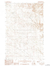
1984 Map of Content NW
USGS Topo · Published 1984About this map
Sevenmile Creek and DHS Creek carve through this section of Phillips County, Montana, defining a landscape of complex coulees and drainage patterns recorded during the late 1970s. The settlement of Chrisson stands as a focal point in an otherwise sparse territory, illustrating the isolated nature of ranching and rural life in the northern plains. This provisional survey captures the section lines and elevation contours that dictated land use and navigation across these prairie highlands. The convergence of numerous unnamed intermittent streams into the larger creek systems reveals the essential role of water management in this arid environment, providing a detailed look at the local geography before subsequent modern developments changed the regional layout.
Find a feature on this map
3 named features on this map. Tap any name to fly to it.
Don’t see what you’re looking for? This feature index may not catch every label — zoom into the map to look around manually.
Map Details
Editions of this 1984 Content NW Map
This is the sole edition of this map. No revisions or reprints were ever made.
Other maps of this area

1905 · Bowdoin
USGS Topo · 1:62,500

1954 · Glasgow
USGS Topo · 1:250,000

1957 · Glasgow
USGS Topo · 1:250,000

1958 · Glasgow
USGS Topo · 1:250,000

1968 · Malta East
USGS Topo · 1:24,000

1984 · Clanton Coulee
USGS Topo · 1:24,000

1984 · Pinks
USGS Topo · 1:24,000
1984 · Horse Pasture Coulee
USGS Topo · 1:24,000
1984 · Mitchell Corner
USGS Topo · 1:24,000
1984 · Content
USGS Topo · 1:24,000