
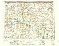
1958 Map of Glasgow
USGS Topo · Published 1958About this map
Glasgow serves as the focal point for this mid-century survey of Northeastern Montana, where the Great Northern railroad dictates the rhythm of commerce along the Milk River. The map captures a transition in the landscape following the massive public works projects of the New Deal era, most notably the expansion of the Fort Peck Game Range and the Fort Peck Indian Reservation. A fascinating detail for local historians is the notation of New Deal (abandoned) and Wheeler (abandoned), two settlements that rose and fell with the construction of the nearby dam. To the north, the agricultural and ranching backbone of Valley County is evident through widely dispersed outposts like the Wendell Post Office and the isolated radar station near Opheim. From the livestock hubs at Malta Stockyards to the irrigation waters of Nelson Reservoir, the map documents an economy defined by rail access and river management.
Find a feature on this map
81 named features on this map. Tap any name to fly to it.
Don’t see what you’re looking for? This feature index may not catch every label — zoom into the map to look around manually.
Map Details
Editions of this 1958 Glasgow Map
2 editions found
Other maps of this area

1905 · Bowdoin
USGS Topo · 1:62,500

1905 · Saco Special
USGS Topo · 1:62,500

1906 · Hinsdale Special Map
USGS Topo · 1:62,500

1910 · Todd Lakes
USGS Topo · 1:62,500

1914 · Nashua
USGS Topo · 1:62,500

1915 · Frazer
USGS Topo · 1:62,500

1915 · Oswego
USGS Topo · 1:62,500

1915 · Todd Lakes
USGS Topo · 1:62,500

1915 · Spring Creek
USGS Topo · 1:62,500

1916 · Nashua
USGS Topo · 1:62,500