
1915 Map of Spring Creek
USGS Topo · Published 1915About this map
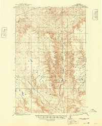
The Fort Peck Indian Reservation dominates this 1915 topographic study of Valley County, Montana. Surveyed just after the turn of the century, the map reveals a landscape defined by its intricate drainage patterns rather than established towns. The main waterway, Porcupine Cr, is joined by the Little Fork Porcupine Creek, cutting through the high plains terrain. Significant local landmarks include the uniquely named Tomato Can creek and the cluster of Todd Lakes on the eastern edge. This era on the reservation was marked by the transition following the Allotment Act, and the lack of structural symbols highlights the vast, open nature of the cattle and horse country before the extensive development of later decades. The intricate contour lines provided by the U.S. Geological Survey illustrate the subtle breaks and coulees that characterize this portion of northeast Montana.
Find a feature on this map
5 named features on this map. Tap any name to fly to it.
Don’t see what you’re looking for? This feature index may not catch every label — zoom into the map to look around manually.
Map Details
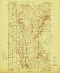
Editions of this 1915 Spring Creek Map
2 editions found
Other maps of this area

1910 · Todd Lakes
USGS Topo · 1:62,500

1914 · Nashua
USGS Topo · 1:62,500

1915 · Frazer
USGS Topo · 1:62,500

1915 · Oswego
USGS Topo · 1:62,500

1915 · Todd Lakes
USGS Topo · 1:62,500

1916 · Nashua
USGS Topo · 1:62,500
1918 · Porcupine Valley
USGS Topo · 1:62,500

1954 · Wolf Point
USGS Topo · 1:250,000

1954 · Glasgow
USGS Topo · 1:250,000

1957 · Glasgow
USGS Topo · 1:250,000