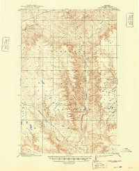
1915 Map of Spring Creek
USGS Topo · Published 1949About this map
The Fort Peck Indian Reservation dominates this 1909-1910 survey of Valley County, showcasing a landscape defined by its intricate drainage systems and seasonal water sources. The map captures the meandering path of Little Porcupine Creek and its tributary, the West Fork Little Porcupine Creek, as they cut through the terrain. To the southeast, the uniquely named Tomato Can Creek flows toward the reservation's borders, while the Todd Lakes area is marked by numerous small depressions and basins, characteristic of the prairie pothole region. This topography, recorded by the General Land Office under Chief Geographer R.B. Marshall, illustrates the open-range character of northeastern Montana before significant modern development. The cartography provides a clear view of the natural water distribution that governed early ranching and land use in Porcupine Valley, from the northern reaches of Porcupine Cr to the southern plains.
Find a feature on this map
7 named features on this map. Tap any name to fly to it.
Don’t see what you’re looking for? This feature index may not catch every label — zoom into the map to look around manually.
Map Details
Editions of this 1915 Spring Creek Map
2 editions found
Other maps of this area

1910 · Todd Lakes
USGS Topo · 1:62,500

1914 · Nashua
USGS Topo · 1:62,500

1915 · Frazer
USGS Topo · 1:62,500

1915 · Oswego
USGS Topo · 1:62,500

1915 · Todd Lakes
USGS Topo · 1:62,500

1915 · Spring Creek
USGS Topo · 1:62,500

1916 · Nashua
USGS Topo · 1:62,500

1918 · Porcupine Valley
USGS Topo · 1:62,500

1954 · Wolf Point
USGS Topo · 1:250,000

1954 · Glasgow
USGS Topo · 1:250,000