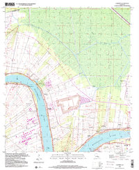
1999 Map of Convent
USGS Topo · Published 2000About this map
Sugar land and river history define this reach of the Mississippi River, where the landscape is organized by the traditional long-lot ribbon patterns of historic Louisiana plantations. From Malarcher Plantation and Uncle Sam Plantation in the north to the iconic Oak Alley Plantation and St Joseph Plantation further south, the map documents the proximity of these riverfront estates to the industrial developments of the late 20th century. The intricate network of drainage canals and the massive levee system protect settlements like Convent and Romeville from the powerful river currents.
Find a feature on this map
44 named features on this map. Tap any name to fly to it.
Don’t see what you’re looking for? This feature index may not catch every label — zoom into the map to look around manually.
Map Details
Editions of this 1999 Convent Map
This is the sole edition of this map. No revisions or reprints were ever made.
Other maps of this area

1892 · Lac Des Allemands
USGS Topo · 1:62,500

1892 · Mount Airy
USGS Topo · 1:62,500

1892 · Donaldsonville
USGS Topo · 1:62,500

1892 · Thibodaux
USGS Topo · 1:62,500

1927 · Thibodaux NW
USGS Topo · 1:31,680

1932 · Lac Des Allemands NW
USGS Topo · 1:31,680

1932 · Thibodaux NE
USGS Topo · 1:31,680

1935 · Gonzales
USGS Topo · 1:31,680

1939 · Donaldsonville
USGS Topo · 1:62,500

1940 · Lagan
USGS Topo · 1:31,680