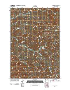
2011 Map of Cook Creek
USGS Topo · Published 2011About this map
The Nehalem River flows through the northern reaches of this Tillamook County terrain, providing a focal point for the small settlements of Salmonberry and Rector. This area is defined by a dense network of drainages and canyons, including Bulck Canyon and Platt Canyon, which feed into the central Cook Creek system. The map documents a rugged landscape managed for timber and recreation, with forestry access provided by routes like Cook Creek Rd and Tin Shack Rd. High-elevation points such as High Butte and Triangulation Point offer clear markers across the drainage divides between the Nehalem and the Miami River. Researchers can trace the complex hydrology of the region through numerous named tributaries like Bastard Creek, Hatchery Creek, and South Fork Cook Creek, which illustrate the geographic character of the Northern Oregon Coast Range in the early 21st century.
Find a feature on this map
40 named features on this map. Tap any name to fly to it.
Don’t see what you’re looking for? This feature index may not catch every label — zoom into the map to look around manually.
Map Details
Editions of this 2011 Cook Creek Map
This is the sole edition of this map. No revisions or reprints were ever made.
Other maps of this area

1937 · Nehalem
USGS Topo · 1:62,500

1937 · Enright
USGS Topo · 1:62,500

1939 · Saddle Mountain
USGS Topo · 1:62,500

1940 · Cape Falcon
USGS Topo · 1:62,500

1941 · Enright
USGS Topo · 1:62,500

1943 · Nehalem
USGS Topo · 1:62,500

1943 · Saddle Mtn.
USGS Topo · 1:62,500

1948 · Vancouver
USGS Topo · 1:250,000

1950 · Vancouver
USGS Topo · 1:250,000

1950 · Vancouver
USGS Topo · 1:250,000