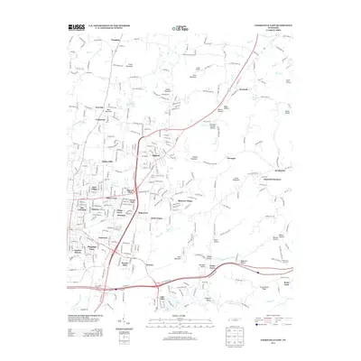
2013 Map of Cookeville East
USGS Topo · Published 2013About this map
Algood serves as the primary hub of this eastern Putnam County landscape, where the residential expansion of Cookeville meets the rising slopes of the Highland Rim. The map documents an intricate network of named residential developments, including White Plains, Darwin Park, and The Lowlands, which contrast with the more dispersed rural settlements like Jeremiah and Bangham to the north. This 2013 survey provides a detailed look at local industry and land use, from the Spring Creek Oil Field in the northeast to the Rocky Point Tree Farm in the southeast.
Find a feature on this map
101 named features on this map. Tap any name to fly to it.
Don’t see what you’re looking for? This feature index may not catch every label — zoom into the map to look around manually.
Map Details
Editions of this 2013 Cookeville East Map
This is the sole edition of this map. No revisions or reprints were ever made.
Other maps of this area

1897 · Standingstone
USGS Topo · 1:125,000

1898 · Standingstone
USGS Topo · 1:125,000

1925 · Gainesboro
USGS Topo · 1:62,500

1929 · Gainesboro
USGS Topo · 1:62,500

1943 · Cookeville
USGS Topo · 1:100,000

1944 · Cookeville
USGS Topo · 1:100,000

1951 · Windle
USGS Topo · 1:24,000

1953 · Cookeville East
USGS Topo · 1:24,000

1953 · Cookeville West
USGS Topo · 1:24,000
1955 · Monterey Lake
USGS Topo · 1:24,000