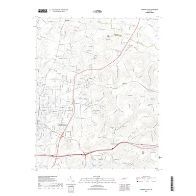
2019 Map of Cookeville East
USGS Topo · Published 2019About this map
Cookeville and the adjacent town of Algood serve as the primary hubs in this portion of Putnam County, where the transition from urban development to the foothills of the Cumberland Plateau is clearly visible. The landscape is defined by a series of prominent elevations such as Algood Mtn, Buck Mtn, and Verble Mtn, separated by deep-cut features like Pointer Hollow and Chimney Springs Hollow. To the north, the county line between Overton Co and Putnam Co cuts through the rural settlements of Bangham and Jeremiah, while the southern reaches are marked by the path of the Falling Water River. Genealogists will find a wealth of local burial sites, including Norris Cem, Paran Cem, and Robinson Cem. Small airstrips like Schiff Airport and water bodies such as Quinland Lake indicate how the modern infrastructure integrates with the natural topography of the Highland Rim.
Find a feature on this map
169 named features on this map. Tap any name to fly to it.
Don’t see what you’re looking for? This feature index may not catch every label — zoom into the map to look around manually.
Map Details
Editions of this 2019 Cookeville East Map
This is the sole edition of this map. No revisions or reprints were ever made.
Other maps of this area

1897 · Standingstone
USGS Topo · 1:125,000

1898 · Standingstone
USGS Topo · 1:125,000

1925 · Gainesboro
USGS Topo · 1:62,500

1929 · Gainesboro
USGS Topo · 1:62,500

1943 · Cookeville
USGS Topo · 1:100,000

1944 · Cookeville
USGS Topo · 1:100,000

1951 · Windle
USGS Topo · 1:24,000

1953 · Cookeville East
USGS Topo · 1:24,000

1953 · Cookeville West
USGS Topo · 1:24,000
1955 · Monterey Lake
USGS Topo · 1:24,000