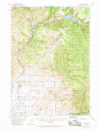
1962 Map of Copco
USGS Topo · Published 1970About this map
Iron Gate Reservoir and Copco Lake dominate the northern landscape of this California-Oregon border region, reflecting the mid-century hydroelectric development along the Klamath River. The survey captures a network of small, rural community centers like Ager and Snowdon, situated along the Southern Pacific Railroad as it snakes through the valley. Educational infrastructure is well-documented, showing the transition of local services through markers like the Willow Creek School, Fall Creek Sch, and the notably marked Foothill Sch (Aban'd). High terrain features such as Bogus Mountain and Black Mtn provide a vertical contrast to the drainage basins of Bogus Creek and the Little Shasta River. These waterways, including Beaver Creek and Jenny Creek, illustrate the complex irrigation and drainage patterns vital to the region's agricultural and forest management within the Shasta National Forest.
Find a feature on this map
69 named features on this map. Tap any name to fly to it.
Don’t see what you’re looking for? This feature index may not catch every label — zoom into the map to look around manually.
Map Details
Editions of this 1962 Copco Map
This is the sole edition of this map. No revisions or reprints were ever made.
Other maps of this area

1886 · Shasta
USGS Topo · 1:250,000

1891 · Ashland
USGS Topo · 1:250,000

1893 · Ashland
USGS Topo · 1:250,000

1894 · Shasta
USGS Topo · 1:250,000

1897 · Ashland
USGS Topo · 1:250,000

1922 · Shasta Valley Sheet No 12
USGS Topo · 1:24,000

1922 · Shasta Valley Sheet No 4
USGS Topo · 1:24,000

1922 · Shasta Valley Sheet No 13
USGS Topo · 1:24,000

1922 · Shasta Valley Sheet No 16
USGS Topo · 1:24,000

1922 · Shasta Valley Sheet No 15
USGS Topo · 1:24,000