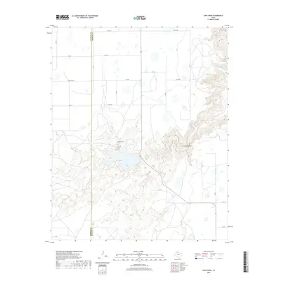
2019 Map of Cope Creek
USGS Topo · Published 2019About this map
Tule Creek Lake sits at the center of this Panhandle landscape, where the flat plains of the Llano Estacado meet the dramatic erosion of the Caprock escarpment. The terrain transitions sharply from orderly section lines and agricultural corridors like Ranch Rd 3300 to the complex drainage systems of Tule Cr and Cope Cr. This transition is most visible at The Narrows, where the elevation drops rapidly into the canyon lands. Recent residential development is concentrated near the lake along streets such as N Mackenzie Rd, Los Lingos Dr, and Lobo Dr. The map also traces the geopolitical boundary between Swisher and Briscoe counties, providing a clear view of how modern transportation networks and land use patterns adapt to the region's formidable geography.
Find a feature on this map
26 named features on this map. Tap any name to fly to it.
Don’t see what you’re looking for? This feature index may not catch every label — zoom into the map to look around manually.
Map Details
Editions of this 2019 Cope Creek Map
This is the sole edition of this map. No revisions or reprints were ever made.
Other maps of this area

1954 · Plainview
USGS Topo · 1:250,000

1958 · Plainview
USGS Topo · 1:250,000

1965 · Ross Canyon
USGS Topo · 1:24,000

1965 · Big Betty Reservoir
USGS Topo · 1:24,000

1965 · Silverton
USGS Topo · 1:24,000

1965 · Rock Creek
USGS Topo · 1:24,000

1965 · Vigo Park
USGS Topo · 1:24,000

1965 · Cope Creek
USGS Topo · 1:24,000

1969 · Love
USGS Topo · 1:24,000

1969 · Jackson Hill
USGS Topo · 1:24,000