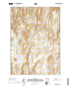
2020 Map of Copeland Reservoirs
USGS Topo · Published 2020About this map
Copeland Reservoirs and a network of artificial water catchments dominate this high-desert reach of Malheur County. The map details a landscape defined by ranching infrastructure, where named reservoirs such as Robinson Reservoir, Kid Flat Reservoir, and McNulty Reservoir collect seasonal runoff for livestock. Topographical landmarks like Copeland Butte provide orientation points across the expansive Antelope Flat, while drainage channels like Butte Creek and Wildcat Creek cut through the terrain. The presence of Slayton Well and Little Mud Flat indicates the critical importance of water management in this arid environment. This 2020 survey records the persistent rural utility of the land, traced by remote corridors like Antelope Flat Road and Crowley Road, reflecting a contemporary ranching economy that relies on these scattered, family-named or location-specific water resources.
Find a feature on this map
31 named features on this map. Tap any name to fly to it.
Don’t see what you’re looking for? This feature index may not catch every label — zoom into the map to look around manually.
Map Details
Editions of this 2020 Copeland Reservoirs Map
This is the sole edition of this map. No revisions or reprints were ever made.
Other maps of this area

1955 · Boise
USGS Topo · 1:250,000

1958 · Boise
USGS Topo · 1:250,000

1962 · Boise
USGS Topo · 1:250,000

1972 · Cedar Mountain
USGS Topo · 1:24,000

1972 · Burnt Flat
USGS Topo · 1:24,000

1972 · Big Mud Flat
USGS Topo · 1:24,000
1972 · Wall Rock Springs
USGS Topo · 1:24,000

1972 · Alder Creek
USGS Topo · 1:24,000

1972 · Rufino Butte
USGS Topo · 1:24,000

1972 · Copeland Reservoirs
USGS Topo · 1:24,000