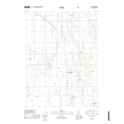
2018 Map of Copic
USGS Topo · Published 2018About this map
The high desert topography of Modoc County is anchored here by the tiny settlement of Copic and the nearby community of Cornell. This 2018 survey documents a landscape defined by volcanic landforms and seasonal water management within the Modoc National Forest. Named islands, including Snake Island, Lands Island, and Stone Island, suggest the historical presence of more extensive surface water in this arid basin, now punctuated by the Mason Reservoir and Harvey Lake. The terrain is characterized by prominent elevations such as Casuse Mtn, Coyote Butte, and Tucker Butte, which overlook broad flats like Dobie Flat and Saddle Blanket Flat. A complex network of county roads, including Co Rd 135 and Co Rd 169, provides access to these remote reaches, while specialized spurs like Tucker Butte Spur and Harvey Lake Spur serve the forest's interior.
Find a feature on this map
42 named features on this map. Tap any name to fly to it.
Don’t see what you’re looking for? This feature index may not catch every label — zoom into the map to look around manually.
Map Details
Editions of this 2018 Copic Map
This is the sole edition of this map. No revisions or reprints were ever made.
Other maps of this area

1886 · Modoc Lava Bed
USGS Topo · 1:250,000

1892 · Modoc Lava-Bed
USGS Topo · 1:250,000

1951 · Clear Lake Reservoir
USGS Topo · 1:62,500

1951 · Tulelake
USGS Topo · 1:62,500

1952 · Timber Mountain
USGS Topo · 1:62,500

1952 · Hackamore
USGS Topo · 1:62,500

1954 · Alturas
USGS Topo · 1:250,000

1958 · Alturas
USGS Topo · 1:250,000

1962 · Alturas
USGS Topo · 1:250,000

1965 · Alturas
USGS Topo · 1:250,000