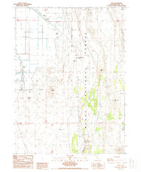
1988 Map of Copic
USGS Topo · Published 1988About this map
Battle of Lands Ranch (Site) and the Battle of Scorpin Point (Site) anchor the historical geography of this northeastern California landscape, marking significant conflict sites within the Modoc National Forest. The map captures a complex water management and agricultural infrastructure established on the edge of Copic Bay, where an extensive system of Levees, a Pipeline, and a Spoil Bank delineate the transition from wetlands to worked land. Former islands like Stone Island, Lands Island, and Snake Island now stand as elevated terrain features amidst the reclaimed flats.
Find a feature on this map
32 named features on this map. Tap any name to fly to it.
Don’t see what you’re looking for? This feature index may not catch every label — zoom into the map to look around manually.
Map Details
Editions of this 1988 Copic Map
This is the sole edition of this map. No revisions or reprints were ever made.
Other maps of this area

1886 · Modoc Lava Bed
USGS Topo · 1:250,000

1892 · Modoc Lava-Bed
USGS Topo · 1:250,000

1951 · Clear Lake Reservoir
USGS Topo · 1:62,500

1951 · Tulelake
USGS Topo · 1:62,500

1952 · Timber Mountain
USGS Topo · 1:62,500

1952 · Hackamore
USGS Topo · 1:62,500

1954 · Alturas
USGS Topo · 1:250,000

1958 · Alturas
USGS Topo · 1:250,000

1962 · Alturas
USGS Topo · 1:250,000

1965 · Alturas
USGS Topo · 1:250,000