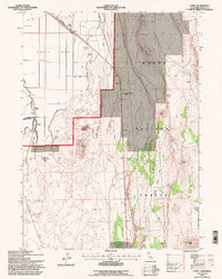
1993 Map of Copic
USGS Topo · Published 1996About this map
The historical conflict sites of Battle of Lands Ranch (Site) and Battle of Scorpion Point (Site) anchor this 1993 study of the California high desert. Situated within the Modoc National Forest, the landscape transitions from the engineering works of Copic Bay—defined by a complex system of Levees, a Ditch, and a Pipeline—to the volcanic topography of Casuse Mountain and Coyote Butte. The rail infrastructure of the Southern Pacific runs through the northern reaches near Copic, where industrial artifacts like Storage Bins and a Pumping Sta reveal the area's agricultural and logistical management. The presence of the Glory Hole Quarry and several Cinder Pits suggests the region's reliance on mineral extraction amidst the arid terrain of Saddle Blanket Flat and Dobie Flat.
Find a feature on this map
34 named features on this map. Tap any name to fly to it.
Don’t see what you’re looking for? This feature index may not catch every label — zoom into the map to look around manually.
Map Details
Editions of this 1993 Copic Map
This is the sole edition of this map. No revisions or reprints were ever made.
Other maps of this area

1886 · Modoc Lava Bed
USGS Topo · 1:250,000

1892 · Modoc Lava-Bed
USGS Topo · 1:250,000

1951 · Clear Lake Reservoir
USGS Topo · 1:62,500

1951 · Tulelake
USGS Topo · 1:62,500

1952 · Timber Mountain
USGS Topo · 1:62,500

1952 · Hackamore
USGS Topo · 1:62,500

1954 · Alturas
USGS Topo · 1:250,000

1958 · Alturas
USGS Topo · 1:250,000

1962 · Alturas
USGS Topo · 1:250,000

1965 · Alturas
USGS Topo · 1:250,000