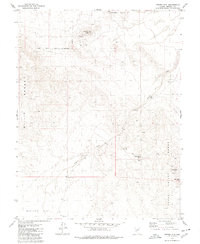
1979 Map of Copper Mtn.
USGS Topo · Published 1980About this map
Nevada Rand Mine and the Golden Pen Mine occupy the eastern slopes of the Gabbs Valley Range, highlighting the mineral extraction efforts in this part of Mineral County during the late 1970s. The landscape is defined by the high prominence of Copper Mtn and the varied terrain of the Koegel Hills and Gillis Range. These ridges are cut by drainage systems like Nugent Wash, which flows toward the southern expanse of Buckley Flat. The northern boundary of the map coincides with the Walker River Indian Reservation, showing where tribal lands meet the public domain. Transportation throughout this arid environment is limited to a network of Jeep Trails, which provide access to several scattered Prospect sites, illustrating the persistent search for ore across these Nevada hillsides.
Find a feature on this map
14 named features on this map. Tap any name to fly to it.
Don’t see what you’re looking for? This feature index may not catch every label — zoom into the map to look around manually.
Map Details
Editions of this 1979 Copper Mtn. Map
This is the sole edition of this map. No revisions or reprints were ever made.
Other maps of this area

1909 · Hawthorne
USGS Topo · 1:250,000

1911 · Hawthorne
USGS Topo · 1:250,000

1915 · Hawthorne
USGS Topo · 1:250,000

1948 · Walker Lake
USGS Topo · 1:250,000

1955 · Hawthorne
USGS Topo · 1:62,500

1957 · Walker Lake
USGS Topo · 1:250,000

1962 · Walker Lake
USGS Topo · 1:250,000

1964 · Walker Lake
USGS Topo · 1:250,000

1964 · Gillis Canyon
USGS Topo · 1:62,500
1979 · Pilot Cone
USGS Topo · 1:24,000